They call it the Mighty Mississippi for a reason. It’s a giant that winds its way from the headwaters in Itasca, MN, all the way down to New Orleans and out to the Gulf. The river was instrumental to the growth of our country. And it’s unintentionally turned out to be the backbone of our adventure.
We started at the bottom, taking the ferry across to downtown New Orleans. Cortney and I rambled up and crossed it again in St. Louis, and have crossed it at least a dozen times or more as we rode into Minnesota.
So in true Ramble Project fashion, we meandered our way up to the source in Itasca. The river isn’t just a thick blue line on the map. We’re now connected those roadways and paths, the bends in the river and small towns and cities that dot the map now. It’s cool.

[This shot above gives you an idea of what it was like coming into Algiers Point, LA, on the west side of the river.]
Cortney and I first crossed the river into New Orleans from Algiers Point. You’re still about a 100 miles from the Gulf, but the Mississippi is massive. This southern section is heavily industrial and all the major oil companies have refineries here. (We rode through them!) The Mississippi River Trail (MRT) wind through industry along roads and levee trail systems.


Heading north into Baton Rouge, there are more industries and refineries, creating miles of an alien landscape. The image on the right shows the view from the top of the Louisiana capitol, and shows how the city is built up along it.

There are also a lot of old port towns on the Mighty Sip. Here you can see what they call Natchez Under the Hill. The French founded Natchez, MS, in 1716. But don’t let its charming looks fool you. It used to be a key hub for the slave trade and had a reputation for being one of the rowdiest ports on the Mississippi River. Taverns, gambling halls, and brothels all lined the street. (It’s just taverns now.)


Our next big crossing was going into St. Louis. The Chain of Rocks Bridge there is unique as it makes a 30-degree turn midway across a mile-long bridge more than 60 feet above the mighty Mississippi. Plus, the bridge was a significant landmark for travelers driving Route 66.

While we were able to cross part of the Chain of Rocks Bridge, the gates were closed on the Missouri side for construction. Luckily, we were able to go down river a bit on the Illinois side and cross at McKinley Bridge. (We love it when there is a separated lane like this for cyclists.)

[This is the bridge in Lacrosse, WI.]
The next time we saw the Mississippi, we were in Lacrosse, WI. This is the heart of the Driftless Area. It’s a really special place geologically. The region was left untouched by the glaciers during the last ice age. And as a result, it showcases steep bluffs, cliffs, and valleys and is really unlike any other place in the Midwest. It’s beautiful.


[Here’s a shot of Cortney on the bridge crossing the river into Winona, MN. And that’s me riding the trail.]
The river was changing even more at this point. Instead of industry and refineries, the focus was really about nature, camping, and resort river towns. It was bucolic and peaceful.


Lake Pepin is the naturally widest part of the Mississippi River and looks like a lake. We rode along the waterfront through touristy Lake City and enjoyed the stunning scenery. We camped at Frontenac State Park, too. There’s a wonderful campground that sits on the bluff with incredible views of the water.


Further upstream, the river flows through the heart of the Twin Cities. It was the flour milling capital of the world at one point, but today the focus has shifted more to recreation. There’s world-class cycling infrastructure that goes along the river and through the cities. It’s all a part of the Great River Road that we’d been following LA, MS, MO, WI and MN.
Riding along the river through all those states, we had to go to the headwaters.


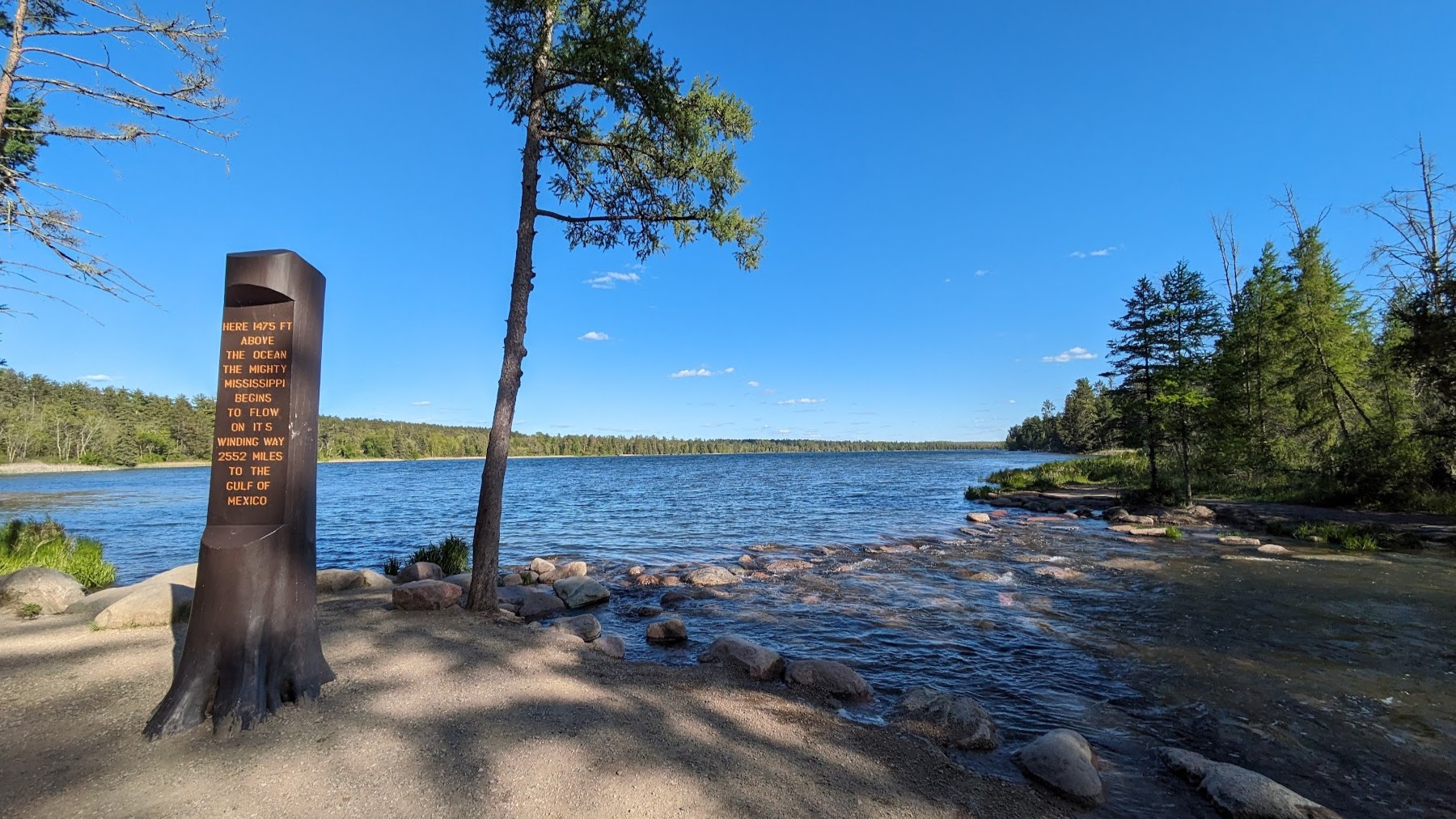
[We made it!]
When we reached Itasca and set up camp, it was early evening. We were tired but there was still plenty of light and the actual headwaters were only a couple miles away. So we made the decision to go then and there, and had the place pretty much to ourselves.
(Fun fact about Itasca: It’s the geographic center of the continent. It’s equally distanced from the Atlantic, Pacific, the Gulf, and Hudson Bay.)
It might not have been the most stunningly beautiful place we’d ever been, but it was a profoundly beautiful moment. We’ve covered a lot of ground on this trip and we still have a ways to go. It’s been a massive physical and emotional undertaking. And to make it this far—and to feel as good as we do—is really something special. We have a deeper connection with the river, the land, and the people.
Sometimes no matter how intentional you try to be, unintended things happen. You discover things you weren’t necessarily looking for. Amazing things.
-Erik
P.S. Thank you to everyone who shared this content or bought us a cup of coffee. And a special thanks to CS, RR, SW, and MS. You guys are awesome!!
Thanks for “The Ramble Project”, Eric and Cortney, I have been enjoying reading about your adventure month by month. Here is a note about the name “Itasca”. This word is the combination of syllables from two Latin words: veritas (meaning truth) and caput (meaning head) … so “true head”, the source of the Mississippi. Best to you on your journey.
Mark
Interesting post! I had no idea. And you know I love history. Stay save. Onward!
*safe